 Aibek · Pexels License
Itinerary · Asia · 14 days · Challenging
The Tian Shan Loop
Bishkek→Ala Archa National Park→Bokonbayevo→Skazka Canyon→Karakol→Jeti-Ögüz+8 stops
Bishkek out and back through the mountains that are ninety per cent of the country - a Chinese mosque built without nails, a three-day crossing over a pass at 3,900 metres between a glacial lake and a hot spring, a lake at 3,016 metres where every building is a yurt and all of them come down in September, and a fifteenth-century caravanserai alone in a side valley near the Chinese border.
Bishkek
A Soviet grid with the Kyrgyz Ala-Too filling the end of every street running south, which is the one thing photographs of the city never carry. Osh bazaar in the morning for whatever you are missing, Ala-Too square for the hourly guard change, and the State Historical Museum, which closed for five years and reopened in 2021 after a restoration that became a national argument about cost. Eat ashlan-fu - cold Dungan noodles in vinegar, sold from carts.
Ala Archa
Forty kilometres south of the city and 2,100 m up at the alplager, which is where the road stops. The walk to the Ak-Sai waterfall and back fills a long day; the climb to the Ratsek hut at about 3,300 m fills a longer one and is the better use of it, because the pass on day eight is six hundred metres higher again and this is the only cheap acclimatisation on the route.
Burana, then the lake
East across the Chüy valley to the Burana tower, an eleventh-century Karakhanid minaret and the only thing standing of Balasagun, a capital that the Mongols took and the ground swallowed. Earthquakes removed roughly the top half of it. The balbals - stone grave markers with faces cut into them - were collected off the surrounding steppe and stood in rows beside it. Then through the Boom gorge to Issyk-Kul and east along the quiet southern shore.
The southern shore
Skazka is red and ochre sandstone eroded into fins and ridges you can walk up in an hour, about two kilometres (1 mi) south of the shore road between Tosor and Kaji-Say. The Soviet resort strip is all on the north shore; what the south has instead is Tamga, where the military sanatorium took cosmonauts - Gagarin convalesced there three times after 1961 - and, forty kilometres (25 mi) further east, the Barskoon valley, which climbs past waterfalls and a monument to him and keeps climbing to the Kumtor gold mine at four thousand metres. That upper road is a working mine road with a checkpoint on it rather than a destination; from the shore you see it as lorries, which is the country's largest export going the other way.
Karakol
The town at the head of the lake, and the only one on the route with a bookshop. The Dungan mosque was put up between 1907 and 1910 by Chinese Muslims who had fled the Qing after the Hui rebellions: painted timber in the shape of a Buddhist temple, assembled without a nail in it. The wooden Holy Trinity cathedral a few streets away replaced a stone church an earthquake brought down, and was finished in the 1890s. If a Sunday falls here, the livestock bazaar on the edge of town starts before six and is a market rather than a display.
Jeti-Ögüz, and the arrangements
Half an hour west: red sandstone cliffs called the Seven Bulls, the split rock beside the road that everyone photographs, and a valley behind them that runs up into the range to a meadow you can reach and return from before lunch. Keep the afternoon for logistics - buy the Karakol valley park ticket, ask somebody who crossed the pass in the last week what is on it, and decide whether you are carrying the gear over or paying a horse and its owner to.
Into the Karakol valley
Taxi to the park gate and walk up the river through spruce forest - roughly 15 km (9 mi) and eight hundred metres of climb to the meadow at Sirota, where tents are hired by the night and the kitchen is a shipping container. Nothing about the day is technical. It is simply long, and it is where you find out what your pack actually weighs.
Ala-Kul and the pass
Up to the lake, which sits at about 3,530 m and is the colour photographs get accused of inventing, then the climb to the pass at roughly 3,900 m (12,800 ft) - loose scree, and slower than the distance on the map suggests. The far side is steeper than the near one. Down the Arashan valley to Altyn-Arashan, where the hot springs at about 2,600 m are piped into concrete baths behind the guesthouses and are the reason to do the crossing in this direction.
Down the Arashan
Soak first, because the day is otherwise all descent. Fourteen kilometres (9 mi) of jeep track along the river to the village at Ak-Suu, walkable in four or five hours and drivable in about one in a Soviet UAZ if your knees have finished arguing. Karakol is twenty minutes on from there: a bed, a shower and somewhere that serves lagman.
West to Kochkor
Along the northern shore, past Cholpon-Ata and its field of Bronze Age petroglyphs pecked into glacial boulders left where the ice dropped them, then south from Balykchy past the Orto-Tokoy reservoir - not west into the Boom gorge, which is the road back to Bishkek. Kochkor is the coordination point for the central pastures - the community tourism office here books the yurts on Song-Kul and the drivers who get you up to them, and the felt shyrdak workshops on the same street are the other reason to stop.
Up to Song-Kul
South and then up the Kalmak-Ashuu switchbacks to a pass at 3,446 m on a track that is under snow for eight months of the year. Song-Kul is at 3,016 m (9,895 ft), about 29 km (18 mi) long, and has no permanent settlement anywhere on it. The yurts go up in June, the herds come up behind them, and the whole arrangement is dismantled and driven off in September. Solar panel, dung stove, no signal, and a long walk to the toilet.
Song-Kul
A day on a horse, hired with its owner rather than on its own, which is how these distances were meant to be covered and what the pasture economy is built around. Otherwise walk the shoreline and watch weather cross the lake from whichever direction it feels like - it can snow here in July, and the cold after dark is what visitors are consistently least prepared for. Bring the layers you would take to a Scottish hill in October.
Naryn and Tash Rabat
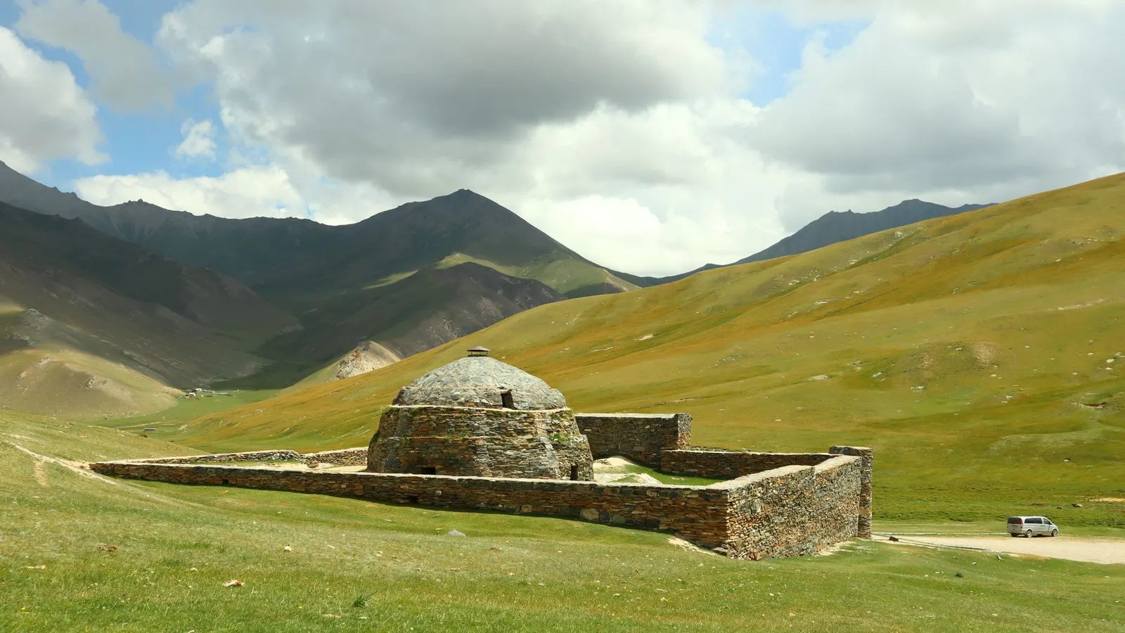
Off the plateau on the eastern track down to Naryn, the highest provincial capital in the country and effectively one street a dozen kilometres long in a canyon, then south-west up a side valley. Tash Rabat is stone, half-sunk into the hillside, thirty-one domed rooms around a central hall, generally dated to the fifteenth century and standing on foundations older than that. There is a yurt camp, a stream and nothing else within an hour in any direction.
Back to Bishkek
The long one out, and longer than the map suggests. Nothing shared leaves from Tash Rabat, so the first leg - down the valley and back through At-Bashy to Naryn, about 110 km (70 mi) - is a car arranged the evening before with the yurt camp. From Naryn the shared taxis go when the fourth seat sells: north-west over the Dolon pass at 3,030 m, through Kochkor, out to the west tip of Issyk-Kul and down the Boom gorge. Roughly 470 km (290 mi) in total, most of it paved. Allow the whole day for it and do not book an evening international departure against it.
Good to know
Everything on this route above about 3,000 metres is seasonal in a way that is not negotiable. The Ala-Kul pass, the Kalmak-Ashuu track to Song-Kul and the Tash Rabat valley are all snowbound outside roughly late June to mid-September, and the yurt camps at altitude are not merely shut out of season - they do not exist, because the families take them down and drive the herds off the pasture. Late July and August are the reliable window; the pass can hold snow into early July in a heavy year, and it is not a place to improvise in trainers. Book the mountain leg through the community tourism networks rather than an agency: the Kochkor and Karakol coordinators publish fixed rates for a yurt bed, a horse with its handler and a 4×4 day, the money goes to the household, and nothing is haggled, which removes an entire category of argument at three thousand metres. All of it is cash, in som, in small notes. The last dependable cash machines are in Karakol, Kochkor and Naryn; there are none at Song-Kul, Tash Rabat or Altyn-Arashan. Shared taxis leave when the fourth passenger appears rather than on a timetable, they go from the western lot in Bishkek for the lake and the south, and buying the empty seat yourself is the accepted way to leave sooner. Most European, British, North American and Japanese passports get sixty days visa-free with no registration, but the Kel-Suu valley, Chatyr-Kul and anything approaching the Torugart pass sit inside the border zone and need a permit that takes six to ten working days to issue and has to be applied for before you leave home, through an agency or the Naryn tourist office - you have to carry the paper original through the checkpoints. Tash Rabat itself does not need one. Two hazards are specific and both are avoidable: shepherd dogs work loose and take the job seriously, so stop short of a yurt and call out rather than walking up to the door, and every stream on this route has livestock grazing somewhere above it, so filter or boil everything, including water that looks as though it came straight off a glacier.
Shorter or longer?
Fly Bishkek–Osh for about €35 - forty-five minutes against twelve hours over the mountains - and add five or six days: Sulaiman-Too, the sacred hill in the middle of the city and the country's only cultural UNESCO site, the walnut forest at Arslanbob, and the road up to Sary-Tash where the Pamir range fills the entire southern horizon.
Bishkek, the southern shore, Karakol and the Ala-Kul crossing, then straight back along the north shore. Keeps the trek and the town, drops Song-Kul and Tash Rabat, and needs no 4×4 at any point.
Practical guide
Visa check for this route
Budget
Mid-range · per person · sharing a double room. Excludes international flights - they depend on where you fly from.
Editorial estimates · checked August 2026
Country guides
Trip essentials
The connectivity placement is our own eSIM store. No affiliate link on this list. How we choose these →