Itinerary · Africa · 14 days · Moderate
Houses of Stone
Harare→Bvumba Mountains→Nyanga→Chimanimani→Chimanimani National Park, Bundi valley→Masvingo+8 stops
The country is named after a building - dzimba dza mabwe, houses of stone - and there are several hundred of them. This crosses Zimbabwe from east to west, from the wet border ridge at Chimanimani to Kalahari sand: the terraced hillsides at Ziwa, Great Zimbabwe itself, Khami, the painted granite of the Matobo, and then off the stone entirely into Hwange, where every drink an elephant takes in October comes out of a borehole.
Harare
Nearly 1,500 metres up, which is why the nights are cold in July and why there is almost no malaria here. Start at the National Gallery of Zimbabwe: the stone sculpture movement that came out of it in the 1960s - Nicholas Mukomberanwa, Bernard Matemera, Henry Munyaradzi - is the country's largest export to the art world and the serpentine it is carved from comes out of the ground a few hours away. Then Mbare Musika for the scale of the informal economy. Draw and count your US dollars today; almost everything on this route is priced in them and change is a constant negotiation.
East to the Bvumba
The A3 to Mutare carries the freight for the Beira corridor, so expect trucks and take the overtaking seriously. Then twenty-eight kilometres up out of Mutare into the Bvumba, whose name means drizzle and which earns it - this ridge takes weather off the Mozambique Channel and can sit inside cloud for a week. Bunga Forest is montane rainforest with samango monkeys in it; from the eastern edge you look straight down into Mozambique.
Nyanga and Ziwa
North along the escarpment. Mount Nyangani is 2,592 metres and the highest ground in Zimbabwe; Mtarazi drops 762 metres off the edge into the Honde Valley in a thread. The reason to come, though, is Ziwa, north of the town: whole hillsides terraced in stone, with walled enclosures and the sunken stone-lined pits that colonial guidebooks called slave pits and which were almost certainly livestock pens. It is an agricultural landscape built by hand and worked into the nineteenth century, and it is the same building culture as Great Zimbabwe applied to farming rather than to a court.
South to Chimanimani
Back down past Mutare and south through Wengezi. Chimanimani village was the epicentre of Cyclone Idai in March 2019 - the storm took out roads, bridges and a large part of the Ngangu township on the slope above, and hundreds of people in this district died. The access road has been rebuilt. Ask locally about trail conditions before committing to tomorrow, because several paths were re-cut from scratch and some are still faint.
Into the Bundi valley
Register at Mutekeswane base camp and walk in - Bailey's Folly is the direct climb, two hours of steep quartzite to the lip, and then the ground opens into the Bundi valley with the mountain hut in it. The ridge above is the international border and Monte Binga, 2,436 metres, stands on the line itself. Skeleton Pass drops into Mozambique and was a supply route during the liberation war. Cloud arrives here without warning; carry a compass and enough to sit it out.
West across the Save
Down out of the highlands and over Birchenough Bridge, a single steel arch of 329 metres flung across the Save in 1935 to a design by Ralph Freeman, who had done Sydney Harbour a few years earlier and reused the shape. It looks absurd in the middle of the lowveld and it is still the crossing. Then a long haul west through Bikita to Masvingo, which is a market town and a fuel stop rather than a destination.
Great Zimbabwe
A full day and it needs one. Climb the Hill Complex first, on the old ascent through the cleft rather than the graded modern path, and see how the walling is fitted between granite boulders instead of replacing them. Down to the Great Enclosure: an outer wall running some 250 metres around, eleven metres high at its tallest, five metres thick at the base, laid dry, and the conical tower inside it - about ten metres of solid stonework with no door, no chamber and no agreed purpose. The site museum holds the soapstone birds. Give the afternoon to the Valley Ruins, which almost nobody walks and where most people actually lived.
Bulawayo and Khami
The A9 across the middleveld. Bulawayo's streets are famously wide because they were laid out to let a full span of oxen turn without unhitching, and the city has been coasting on that grid ever since; the Railway Museum is the best thing in it and the National Gallery in the old Douslin House the second. In the afternoon go 22 km west to Khami, the capital of the Torwa state built after Great Zimbabwe emptied, where the walling is decorated in chevron and chequer patterns across long terrace faces. It went up in UNESCO's 1986 list alongside Great Zimbabwe and gets a fraction of the visitors.
Into the Matobo
An hour south into granite that has weathered into domes and balancing stacks - Mzilikazi's people called them the bald heads. Malindidzimu, the hill Cecil Rhodes had himself buried on in 1902, is a Ndebele sacred site he chose for the view; the Shangani Patrol memorial is beside him and the argument about whether either should still be there is live. Pomongwe and the shelters around Maleme carry rock art painted over thousands of years by people whose descendants are not here, and the hills hold working Mwari shrines that are nothing to do with tourism.
Rhino on foot
Out at first light with a parks scout or a licensed operator, on foot, tracking white rhino through the boulder country. Matobo carries one of the more durable rhino populations in the region and the reason it works is that the terrain hides them and the scouts know it metre by metre. Afterwards Nswatugi Cave, which has some of the finest painted giraffe and kudu anywhere in southern Africa, then back to Bulawayo to fuel and resupply for the west.
North-west to Hwange
The A8 through Nyamandhlovu, Lupane and Gwayi - tarred, straight, busy with timber and coal trucks - then 25 km in off the highway on a broken strip of tar to Main Camp. You cross onto Kalahari sand somewhere past Gwayi and the change is total: on this side of the park there is no rock, no perennial river and, by the end of the dry season, no natural standing water at all. Hwange is 14,651 square kilometres and the northern third around Sinamatella is a different country - basalt, hills, seasonal rivers - which is why that side needs a 4WD and this one does not. Book the camp before you leave Bulawayo and buy your food there; Main Camp sells almost nothing.
The pumped pans
South on the sand roads through Kennedy to Ngweshla, which is the pan circuit most people drive and which is worth the shaking. Every pan you sit at in the dry season is fed by a borehole - diesel or, increasingly, solar. ZimParks runs them, but a large share of the boreholes, the fuel and the maintenance is carried by conservation trusts and donors rather than by the parks budget, and the pumping season is a fundraising season. Hwange's elephant population, counted in the tens of thousands and among the largest anywhere, is a direct function of whether those pumps keep up: in the El Niño drought of late 2023 they did not, and elephants died at the pans in numbers that made the international news. This is a watering system somebody has to pay for, not a wilderness. Sit at one pan for two hours instead of driving between six. Nyamandhlovu platform near Main Camp is the reliable evening option if the sand defeats you.
The Zambezi
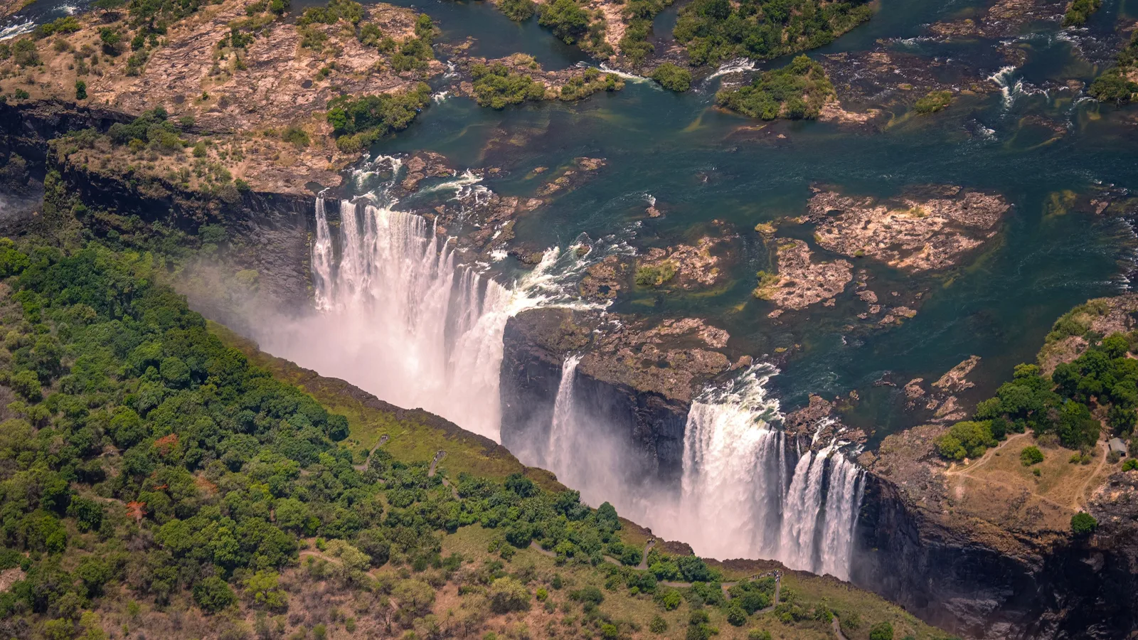
Back to the A8 and north-west. Mosi-oa-Tunya is 1,708 metres wide and drops 108 metres at the deepest point, and the Zimbabwean side holds most of the viewpoints - sixteen of them along the rainforest path, which is rainforest because of the spray and is the only place in the country where it rains every day. Walk the whole path to Danger Point. The bridge below opened in September 1905, a 156-metre arch built for Rhodes' Cape-to-Cairo railway, and trains still cross it.
Upstream and downstream
Zambezi National Park runs forty kilometres up the river from the falls and is the quietest game drive of the whole trip because everyone is at the waterfall. Downstream, the Batoka Gorge is where the river goes after the drop; the rafting season runs roughly August to December when the water is low enough, and a hydro scheme has been proposed for that gorge by the two governments for decades without being built. Drive the river road at dusk and finish there.
Good to know
Zimbabwe runs on US dollars in practice - fuel, park fees, lodges and most shops quote and prefer them - while the local unit, the ZiG, was introduced on 5 April 2024 and is what you will be handed as change. Bring clean, untorn, small-denomination notes: a US$100 bill is often unusable and nobody at a park gate can break it. Cards work in Harare, Bulawayo and Victoria Falls hotels and nowhere else on this route, so carry the whole trip's gate money in cash. Fuel is sold in US dollars and the supply is not uniform: Harare, Mutare, Masvingo, Bulawayo and Victoria Falls are dependable, the A8 west of Bulawayo is not, and there is no pump inside Hwange you can plan around - fill in Bulawayo, top up at Dete or Hwange town, and carry twenty litres in a jerrycan for the sand. ZimParks charges non-residents entry per person per day plus a vehicle fee at Hwange and Matobo, and accommodation inside the parks is a separate booking that goes months ahead for Hwange in August and September; Great Zimbabwe, Khami and Ziwa are National Museums and Monuments sites with their own tickets, and the Victoria Falls rainforest is a separate US$50 per person that is not covered by anything else. Self-drive is genuinely realistic here - the A3, A9 and A8 are tarred and the Matobo and Main Camp loops are passable in a 2WD in the dry - but a high-clearance vehicle is the difference between reaching Ngweshla and turning back, and Sinamatella's side of Hwange needs 4WD. Police roadblocks are routine and they check equipment: two red warning triangles and a fire extinguisher are legally required in every vehicle, a reflective vest is asked for often enough to count, and a missing item is a spot fine - confirm all three are in the car before leaving the hire yard. Do not drive at night anywhere on this route - unlit vehicles, cattle and pedestrians on unlit verges are the real hazard, not crime. Malaria is present in the Zambezi Valley, at Victoria Falls, across Hwange and in the eastern lowveld, year-round with a November-to-May peak; Harare, Bulawayo, Nyanga and the Bvumba are high enough to be low risk, but prophylaxis makes sense for a trip that includes the western half. A yellow fever certificate is required only if you are arriving from, or have spent more than twelve hours in, a country with risk of transmission - a direct flight from Europe or Johannesburg does not trigger it, a connection through Nairobi or Addis Ababa can. Seasons pull in opposite directions: Hwange is at its best from August to October, when the pumped pans are the only water and the game stacks up on them, and scatters after the November rains, while the Eastern Highlands are walkable and clear from April to September and sit in cloud from December to March. The falls are at maximum flow around March to May, when the spray hides them, and at their thinnest from September to November, when you can see the rock. Most nationalities get a visa on arrival; the KAZA UniVisa covering Zimbabwe and Zambia for thirty days is US$50 and available at Victoria Falls and Harare, but it has been suspended and reinstated more than once, so confirm it is being issued before planning a crossing around it. Finally, this route is one-way: it ends at Victoria Falls, which has an international airport with flights to Johannesburg, Nairobi and Addis Ababa, so you do not drive back. Hire companies charge a one-way drop fee - a few hundred dollars - for leaving the car there instead of returning it to Harare, and it has to be agreed when you book, not argued about on the day.
Shorter or longer?
Add four or five days at the beginning: Harare to Kariba, then down the escarpment at Marongora and 76 km of gravel into Mana Pools, which is one of very few parks in Africa where you may walk unguided. The road in is closed for the wet season, roughly January to March, and most visitors fly in by light aircraft from Harare instead - budget for the charter if you do. Rejoin the route at Harare.
Cut the Eastern Highlands entirely - days two to five - and drive Harare to Great Zimbabwe direct, about 320 km on the A4 through Masvingo. Keeps Great Zimbabwe, Khami, the Matobo and Hwange, loses the mountains, Ziwa and the one day of real walking.
Practical guide
Visa check for this route
Budget
Mid-range · per person · sharing a double room. Excludes international flights - they depend on where you fly from.
Editorial estimates · checked August 2026
Country guides
Trip essentials
The connectivity placement is our own eSIM store. No affiliate link on this list. How we choose these →